 BBC
BBCA ceasefire has come into effect between Israel and Hezbollah in Lebanon after a deal was agreed to end 13 months of fighting.
In October 2023, Hezbollah began firing rockets at Israel in support of its ally Hamas in Gaza and Israel launched retaliatory air strikes in Lebanon.
The conflict escalated in late September 2024, when Israel launched an intense air campaign and ground invasion of southern Lebanon.
In Lebanon, more than 3,800 people have been killed since October 2023, according to Lebanese authorities, with one million people forced to flee their homes.
On the Israeli side, at least 82 soldiers and 47 civilians have been killed, while 60,000 people have been displaced, Israeli authorities say.
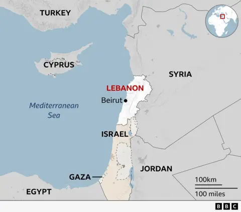
Map: Where is Lebanon?
Lebanon is a small country with a population of about 5.5 million people, which borders Syria to the north and east, Israel to the south, and the Mediterranean Sea to the west. It is about 170km (105 miles) away from Cyprus.
What has been agreed in the ceasefire?
Under the terms of the ceasefire, Hezbollah must end its armed presence in the area of southern Lebanon between the Blue Line – the unofficial border between Lebanon and Israel – and the Litani River, about 30km (20 miles) to the north.
Over the next 60 days, Israel will gradually withdraw its forces from southern Lebanon and thousands of Lebanese army troops will move into the vacated positions in parallel, the agreement says.
The Lebanese army will ensure that Hezbollah’s infrastructure or weaponry is removed and that it cannot be rebuilt, according to a senior US official.
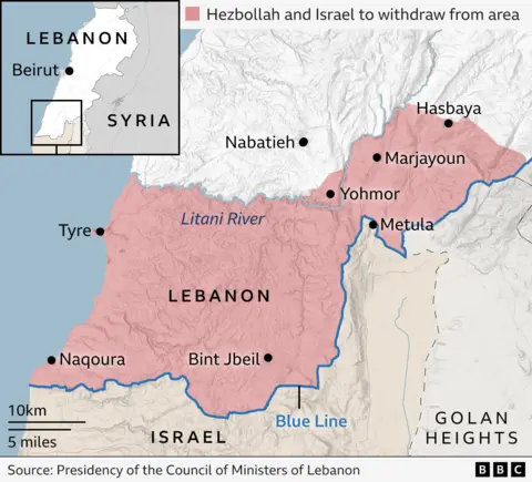
Under UN Security Council resolution 1701, which ended the last war in 2006, the area south of the Litani should be free of any armed personnel or weapons other than those of the Lebanese state and the UN peacekeeping force (Unifil). However, both sides claimed violations of the resolution.
The US and France will join the existing tripartite mechanism, involving Unifil, Lebanon and Israel, which will be charged with monitoring violations, the senior US official said.
The agreement also says that “these commitments do not preclude either Israel or Lebanon from exercising their inherent right of self-defence, consistent with international law”. Israel’s prime minister insisted it would “maintain full freedom of military action” to attack Hezbollah if it violated the agreement.
Tens of thousands of Lebanese civilians displaced by the war have started returning to their homes in the south, despite being warned by the Israeli military that it was not safe to return to areas where its soldiers were still deployed.
Where were Israel’s ground operations?
Israel launched its ground invasion of southern Lebanon on the night of 30 September 2024, with troops and tanks crossing the border in several locations.
The Israel Defense Forces (IDF) said it was carrying out “limited, localised, and targeted ground raids” to dismantle what it called Hezbollah’s “terrorist infrastructure”.
Analysis by experts at the Institute for the Study of War suggests Israeli ground operations were limited to areas within a few kilometres of the border, as shown in the map below.
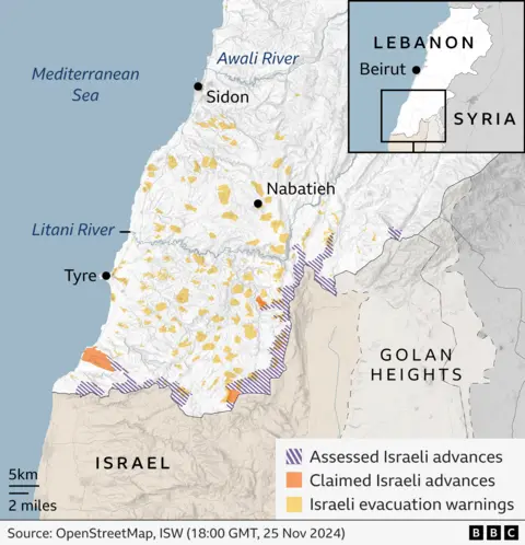
The IDF warned people living in dozens of towns and villages in southern Lebanon to leave their homes and head north of the Awali River, which meets the coast about 50km (30 miles) from the border with Israel.
Lebanese civilians were also told by the IDF not to use vehicles to travel south of the Litani River.
What did Israel’s air strikes target?
The IDF carried out air strikes in Lebanon throughout the conflict.
But it sharply escalated the air campaign on 23 September 2024, when it launched an operation targeting what it said were Hezbollah infrastructure sites and weapons in all areas of the country where the group has a strong presence.
However, Lebanese authorities say more than 700 women and 200 children have been killed since the start of the conflict, as well as another 200 people working in the country’s health sector.
As the chart below shows, the intensity of the strikes stepped up significantly in the weeks before the Israeli ground invasion in late September and peaked in October.
The majority of Israeli strikes were in southern Lebanon, where about a million people lived before the conflict escalated over a year ago.
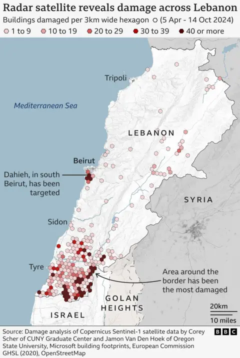
The map below – using analysis of satellite data by Corey Scher of CUNY Graduate Center and Jamon Van Den Hoek of Oregon State University – shows which areas of Lebanon sustained the most concentrated damage during the conflict.
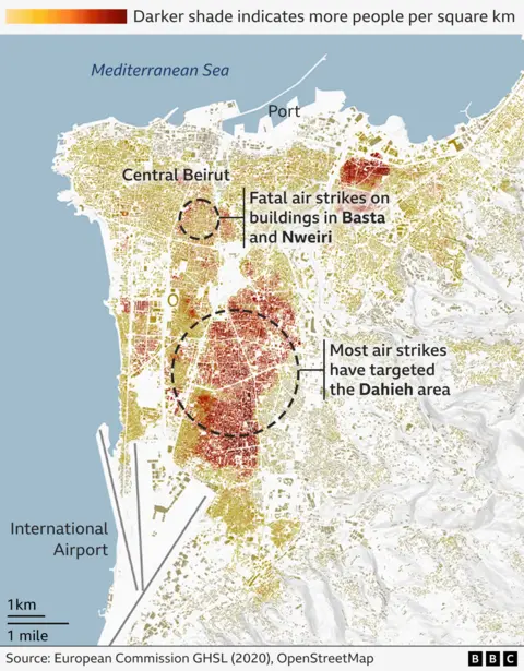
As the following map shows, Beirut was also heavily targeted by Israeli air strikes.
There were some strikes close to central Beirut but the majority of them hit the southern suburbs of the city – densely populated areas that were home to hundreds of thousands of civilians.
These areas, close to the international airport, have a strong Hezbollah presence and it was a series of strikes on buildings there that killed Hezbollah leader Hassan Nasrallah on 27 September.
There were several dozens air strikes in the southern suburbs and central Beirut on 26 November hours before the ceasefire deal was agreed.
How does this fit in with wider Middle East conflict?
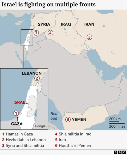
Israel has a decades-long history of conflict with Hezbollah in Lebanon but it is just one of the fronts that it is currently engaged in hostilities.
The others include armed forces and non-state armed groups in several countries in the Middle East, including Iran, Syria and Iran-backed groups operating in Gaza, Iraq, Syria and Yemen.
