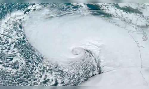
The Weather Prediction Centre issued excessive rainfall risks through Friday and hurricane-force wind warnings were in effect as the strongest atmospheric river — a large plume of moisture — that California and the Pacific Northwest has seen this season overwhelms the region. The storm system is considered a “bomb cyclone”, which occurs when a cyclone intensifies rapidly.
Downed trees struck homes and littered roads across northwest Washington. In Lynnwood, Washington, a woman died Tuesday night when a large tree fell on a homeless encampment, South County Fire said in a statement on X.
In Seattle, a tree fell onto a vehicle, temporarily trapping a person inside, the Seattle Fire Department reported. The agency later said the individual was in stable condition.
“Trees are coming down all over the city and falling onto homes,” the fire department in Bellevue, about 10 miles (16 kilometers) east of Seattle, posted on the social platform X. “If you can, go to the lowest floor and stay away from windows. Do not go outside if you can avoid it.”
Early Wednesday, over 600,000 houses in Washington State were reported to be without power on poweroutage.us. But the number of outage reports fluctuated wildly throughout the evening likely due in part to several weather and utility agencies struggling to report information on the storm because of internet outages and other technical problems. It wasn’t clear if that figure was accurate. More than 15,000 had lost power in Oregon and nearly 19,000 in California.
As of 8 pm, the peak wind speed was in Canadian waters, where gusts of 101 mph (163 kph) were reported off the coast of Vancouver Island, according to the National Weather Service in Seattle. Along the Oregon coast, there were wind gusts as high at 79 mph (127 kph) Tuesday evening, according to the National Weather Service in Medford, Oregon, while wind speed of 77 mph (124 kph) was recorded at Mount Rainier in Washington.
Winds were expected to increase in western Washington throughout the evening, the weather service said.
The national Weather Service warned people on the West Coast about the danger of trees during high winds, posting on X, “Stay safe by avoiding exterior rooms and windows and by using caution when driving.”
In northern California, flood and high wind watches were in effect, with up to 8 inches (20 centimeters) of rain predicted for parts of the San Francisco Bay Area, North Coast and Sacramento Valley. Dangerous flash flooding, rock slides and debris flows were expected, according to the National Weather Service Weather Prediction Centre.
A winter storm watch was issued for the northern Sierra Nevada above 3,500 feet (1,066 metres), where 15 inches (28 centimeters) of snow was possible over two days. Wind gusts could top 75 mph (120 kph) in mountain areas, forecasters said.
The National Weather Service issued a flood watch for parts of southwestern Oregon through Friday evening, while rough winds and seas halted a ferry route in northwestern Washington between Port Townsend and Coupeville.
A blizzard warning was issued for the majority of the Cascades in Washington, including Mount Rainier National Park, starting Tuesday afternoon, with up to a foot of snow and wind gusts up to 60 mph (97 kph), according to the weather service in Seattle. Travel across passes could be difficult if not impossible.


